I failed to start this topic earlier because of server's problems, I'm glad it's working nowMay 17It seemed to me like not a special day... the forecast told about cloudy skies with drizzle (morning-afternoon) and moderate rain in the evening. But after looking ESTOFEX I turned more optimistic, and this time it was almost completely correct!

Now here is the forecast
(...)
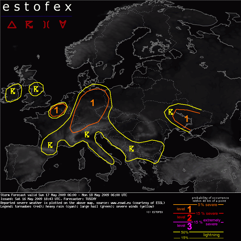
A level 1 was issued for Ukraine mainly for severe wind gusts and large hail.
SYNOPSIS
A broad vortex is placed over NW-Europe with some WAA downstream over central Europe. Another but much weaker upper trough is situated south of Greece and just slow forward propagation to the east is expected. NE-Europe gets affected by cool and stable air while hot and stable conditions prevail over the southern Iberian Peninsula. A SW-NE aligned surface boundary over SE-France and Germany serves as focus for thunderstorm initiation as it moves constantly to the east.
DISCUSSION
(...)
... Ukraine ...
An eastward sliding cold front serves as focus for scattered thunderstorms during the day. Mid-level jet arrives from the west with winds increase to 25m/s at 500hPa and so does the DLS, which augments to near 20m/s. The jet chops the front in a right angle and a forward propagating MCS likely evolves with an attendant severe wind gust and isolated large hail risk. During the evening hours, this MCS will exit the forecast area to the east. As the LLJ remains quite weak during the forecast period, no widespread wind damage is expected, which would require a level-2, but degree of moisture and instability but also sounding reports are monitored for a more serious wind damage risk.
So, the 'level 1' was issued for Poltava, they even told about possible 'level 2'
Now let me tell very shortly about what actually happened. I'm sorry to say but I have extremely few time now, so I do not post any photos/videos, and I may not do it until next week.

The morning and afternoon were the same as forecasted: cloudy (Sc, Ns, St), a bit of gentle rain (8AM), temp-s up to +20C.
The main action occured in the evening... a 'calm' t-storm very unexpectedly brought some severe severe weather

I heard thunder sounds since 4PM, at first they were very weak, next they occured closer. Since ~17:20 it started raining with pauses (while clouds passed across). I seen a few flashes of lightnings but kept working inside the house.
And here it started! At 18:20 I heard a specific loud noise - as the rain droplets fall on the metallic roof of my balcony during a heavy rainfall. In a few minutes I grabbed a camera and standed at the balcony window. The rainfall became more and more powerful. More and more, the rivers were pooring down from the roof...
I observed an interesting phenomenon - double rain

(the heavy droplets falled with amazing speed vertically down, and the tiny droplets were chaotically flying as a tiny clouds forced by strong wind). This nasty rainfall during a single moment turned the windows wet, myself wet too... next I feeled ice with my feet!

yes, it was hail laying on the floor. It was hard to distinguish it from large droplets visually (they were white too), but I was sure when I touched the hailstones (up to 1cm) with my fingers. It was the first hail this year, though it lasted for only 1-2 minutes. Also seen ca.5 lightnings (weak) during the greatest storm.
The rainfall was extremely heavy for a few moments, and I looked into an opened window with a camera in my hands at my own risk.
Got several videoclips and 2 images.
Rainfall quickly ended 10 minutes later (18:25-18:35). The roads in the yard were like a small lake - completely in water. Total 6mm falled per 10 minutes!! (total 24h precip. = 9mm).
All action ended until 8PM.
I can say this show was almost worth for 'level 1' alert received.

