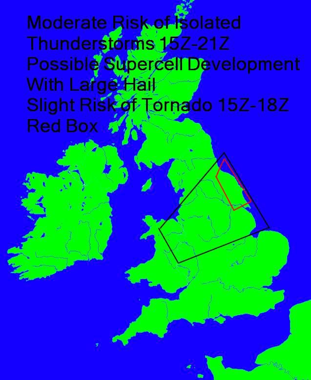
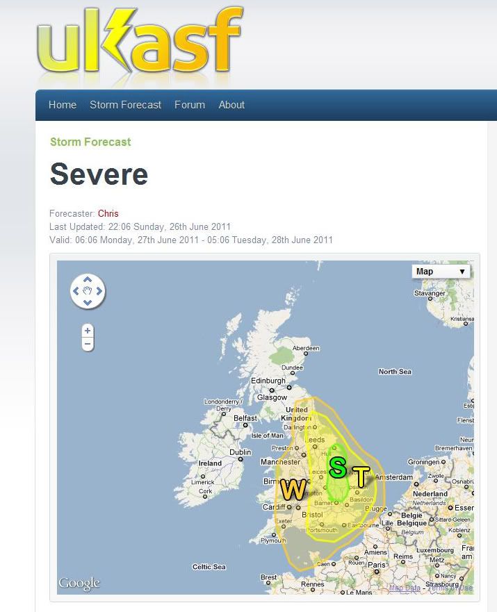
Astronomy, Photography and Weather
April 20, 2024, 03:53:59 am
Welcome, Guest. Please login or register.

Login with username, password and session length
News: IAA lecture programme continues alternate Wednesdays from September - an excellent programme of lectures- Queens University Belfast - Bell Lecture Theatre. Also keep an eye out for the Summer Events
 
  Home Help Search Gallery Staff List Login Register  
  Show Posts
Pages: 1 [2] 3 4 ... 51
16  General Category / Weather & Atmospherics / Re: Spanish Plume/Severe Storms? - England/UK - Mon & Tues June 27th & 28th on: June 27, 2011, 01:45:32 am


Areas Affected:
Most of England and Wales (only focusing on UK areas)

Discussion:
Very tricky situation for Monday afternoon into Tuesday morning...

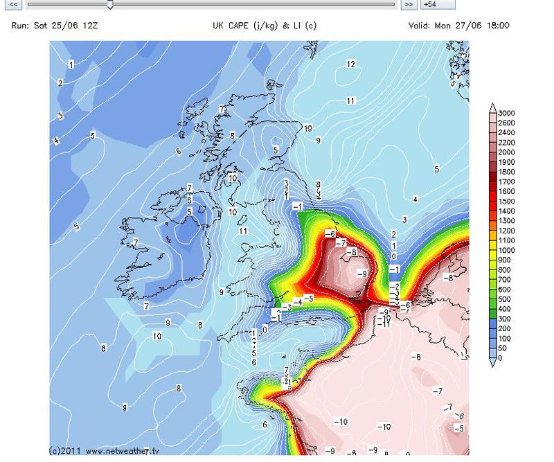
Overall set-up...Large upper trough located to the west of the British Isles over the Atlantic will dig in through the day, spreading areas of PVA across much of the country. Very warm to hot and humid surface air will be in place, particularly across southern/eastern Britain where temperatures could near or exceed 30C in places and dew-points could exceed 20C will provide some of the ingredients necessary for strong to potentially severe thunderstorms in the Severe & Thunderstorm warned area. A breakdown of the areas can be found below:

Severe area: (a portion of E England)...I will stress before I begin, the risk of afternoon thunderstorm development is particularly low, however if any do develop they could become severe...Some of the warmest surface temperatures will be located in this area upper 20s to near 30C possible. Along with dew-points in the low 20s this could produce CAPE values in the region of 2000j/kg. Deep layer shear values will be near 35-40kts in this region, enough to separate updraft/downdraft regions and potentially produce a few mesocylones/supercell thunderstorm IF afternoon, surface based convection can develop. Cap strength will likely be fairly strong as upper ridge is slow to clear the east of England. This will produce a dry/warm layer separating the hot humid surface air from the cooling upper level air above it. At the moment, both NAE and GFS are reluctant to break the cap and produce this surface based convection, so chances of it occurring are in the 20% realm, however if they do develop they would do so quickly and produce severe weather with the potential of large hail (up to 2.5cm), strong gusty winds, particularly given the drier mid-layers, frequent CGs and potentially a few isolated tornadoes. - Low level shear is in the range of 15-20kts and SSE to SSW surface convergence is possible in this region, indicated by the 12z NAE.

Thunderstorm Area: (S and E England) This area will be monitored for mid-level instability thunderstorms which are likely to develop across France during the afternoon and move northward across the area during the evening and overnight. Lightning (mostly in cloud), gusty winds and some hail could be associated with these elevated storm even into Tuesday morning in East Anglia and Eastern England.
17  General Category / Weather & Atmospherics / Re: Spanish Plume/Severe Storms? - England/UK - Mon & Tues June 27th & 28th on: June 27, 2011, 01:39:20 am
11pm Sun

Moderate Risk of Thunderstorms N.Wales & Northern UK 15Z-21Z

Prime Risk Large Hail & CG's

Slight Risk of Tornado Development 15Z-18Z as per red box

Currently some broad variation within the models ATM. Though for me based on the GFS I see a prime region for strong convection as per map below. In fact based on the overlay of strong CAPE values to vertical shear we will have the basis for supercell development. I am further encouraged by a very dry incursion within the mid levels which is likely to increase lapse rates quite dramatically. As Chris mentioned, vertical shear should sustain an isolated storm long enough for large hail to build within the updraft. Some strong convective gusts are possible though likely to be non severe!

My attention is primarily drawn to a small zone where low level direction shear turns a full 90 deg (red box). The convergence closer to the coast could well trigger a tornado or two. Winds above 850 mb look fairly straight lined so not sure if any mesocyclone development will extend upwards into the mid level efficiently.

The larger picture may well see some minor convective storms develop across other parts of the UK though dynamic lift looks rather weak for anything substantial. Hence my focus within the convective box below!


CREDIT: Tony Gilbert
18  General Category / Weather & Atmospherics / Re: Spanish Plume/Severe Storms? - England/UK - Mon & Tues June 27th & 28th on: June 25, 2011, 09:07:22 pm
Still on course for Monday!!

19  General Category / Weather & Atmospherics / Re: Spanish Plume/Severe Storms? - England/UK - Mon & Tues June 27th & 28th on: June 23, 2011, 11:46:55 pm
Absolutely mouthwatering charts!!  Crazy crazy figures those with explosive convective potential, yes they will be downgraded (downgraded on the 18z run) but nice to see this showing up, if nothing else but to get a bit of banter going-i will definitely be watching developments over the weekend.
20  General Category / Photography / Re: Cornwall again on: June 23, 2011, 11:30:27 pm
Great photography Anton, i have to go with no.2 as well the movement in the sky and sea works well with a nice scene.
21  General Category / Weather & Atmospherics / Re: 2011 Noctilucent Cloud Season on: June 20, 2011, 11:27:34 pm
Only getting a chance to post these up now, this is the morning of he 18th June taken around 03:00. I had consumed a few beers earlier in the night so couldnt get to a scenic location, these taken in my front garden from town. Quite an extensive display and quite bright towards the horizon.


22  General Category / Photography / Re: Toome Bridge Night Exposures on: June 20, 2011, 11:16:19 pm
I think these are amazing, what a great subject this is and the car trails and shadows coming off the bridge work so well, 3 and 4 do it for me. I bet you got some strange looks at the side of the road at that hour of the morning  Smiley
23  General Category / Weather & Atmospherics / Re: Saturday's unstable skies on: June 20, 2011, 11:08:39 pm
Class stuff John, im going with no.8 as my favourite but they're all good  Smiley
24  General Category / Weather & Atmospherics / Re: Sun Pillar on: June 20, 2011, 11:04:24 pm
What a cracker Richard- wow, greats shots
25  General Category / Photography / Re: Mishmash 2 on: June 16, 2011, 05:14:15 pm
First is a cracker Richard, really great shot.  Looks like you have a nice setting there for your home, id love to move back to the countryside.
26  General Category / Weather & Atmospherics / Re: 2011 Noctilucent Cloud Season on: June 16, 2011, 05:09:43 pm
Very nice images Martin, love that location and the bridge  Wink
27  General Category / Weather & Atmospherics / Re: 2011 Noctilucent Cloud Season on: June 16, 2011, 12:43:51 pm
Two from the morning of the 16th June


28  General Category / Astronomy & Space / Re: Blurry Ha Full Disk - 14th June on: June 14, 2011, 11:32:45 pm
Excellent Mark!!
29  General Category / General Forum / Re: Website disruption on: June 14, 2011, 11:23:26 pm
Yeah Anton i had some trouble getting on earlier, seems fine now
30  General Category / Weather & Atmospherics / Re: 2011 Noctilucent Cloud Season on: June 14, 2011, 11:08:07 pm
Thanks all, a great little find this lake i must say and to think its only 10 miles away and last night was my first time there (shame on me).  The combination of moonlight, mist hanging over the water and the NLC made for a wonderful experience.   Heres a few more..


Pages: 1 [2] 3 4 ... 51
Bookmark this site! | Upgrade This Forum
SMF For Free - Create your own Forum

Powered by SMF | SMF © 2016, Simple Machines
Privacy Policy